Mini Floating Menu
The mini SGT menu is shown to the left. In the tool you can click on a question/section number and it will take you to that page. There are links included to take you back to this page, view the report or reset the tool. Below are the controls of the mini SGT menu (hover over links to view description of function) .
Summary:
Tabbed information interface
These tabs are viewed for each of the questions. The colour scheme of the tabs quickly lets you know what information is available for each question/section. Click on the coloured tabs below for a brief summary of types of information to expect.
An overview of the section, with a text area for you to add any comments relevant to the question
Tool related knowledge retrieved from the database
Information and guidance related to the section
Relevant text from a worked case study
Report guidance
Saving
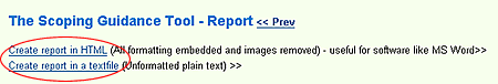
In order for the user to create a report that can be saved locally, not only do relevant stages of the tool require completion, but a report has to be generated on the web server. This can easily be done by clicking one of 'create report' links at the top of the report page (as highlighted below).
Any text formatting like line brraks, bold etc, that you paste into a textbox will be lost when adding text to the report. However, formatting can be applied by using basic HTML tags. Some examples are below
Use <br /><br />
to start another paragraph or <br />
to start a new line
<strong>bold</strong>, <em>italic</em> or <u>underline</u>
Formatting demonstration
As entered into the textbox:
<strong>Seaforth River Terminal - Mersey Estuary UK</strong><br />The proposal will be carried out in two phases. Phase 1 involve the berth construction and will include the following elements:<ul><li> The construction of a new wall (approximately 750m long) between the southwest corner of Seaforth and along the low water edge of an intertidal area known as ‘<em>Seaforth Triangle</em>’. </li><li> The deepening an area of the river bed in front of the proposed terminal (to -15m CD) to create a 40m wide ‘Berth Pocket’ that will allow Post Panamax vessels to berth in this area.</li><li> The reclamation of the Seaforth Triangle area behind this new wall (using materials dredged during Berth Pocket deepening work).</li></ul> Phase 2 will involve the deepening of the Outer Estuary access channel to the proposed River Terminal. Initially MDHC will operate this new terminal with the approach channel retained at its existing declared navigable depth of -6.9m CD.<br /><br /> Within 10 years of the quay wall completion MDHC also propose to deepen shallower areas (mainly the Formby Bar and Crosby Shoal) in the Outer Estuary navigation channel to -8m CD.
As viewed in the online and HTML report :